Every cyclist I meet on long distances routes seems to have their own unique approach to navigation. Some are dedicated map users, while others have committed entirely to electronic means.
When I set out to cycle around the North Sea, I did a bit of research to see what would be an optimal strategy for each country I would cycle through, while keeping the weight to an acceptable limit. I did not want to carry too many maps. I used a combination of the following:
- Google Maps
- Google MyMaps
- Viewranger (Android and iOS)
- Backcountry Navigator Pro (Android)
- Garmin 520
- Paper Maps
- Signposts
- Intuition
Each method has its uses, depending on the circumstances.
Google Maps
Mobile 4G coverage in Europe, even in remote locations, was excellent. Perhaps not so in the remote areas of the UK. It is also ‘free’, now that mobile roaming charges have been abandoned, or at least, it should costs you no more than your host country data tariff (please check before travelling). That means I could use Google Maps on my Pixel Smartphone without worrying about a big bill when I got home.
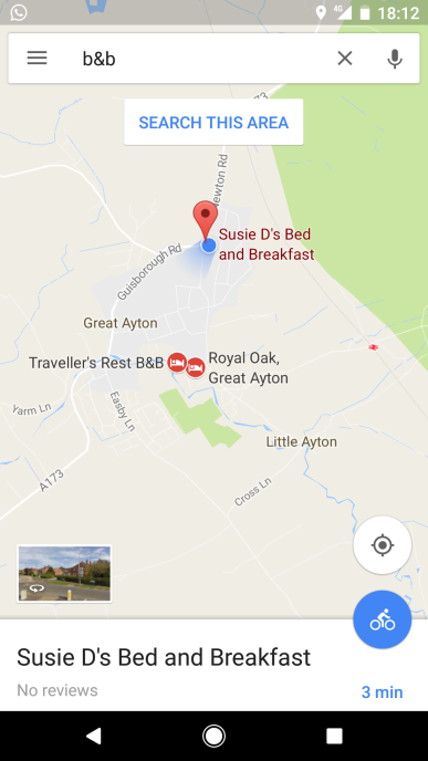
The primary use of Google Maps is to find campsites, shops, restaurants, cycle shops etc. You just centre on your location and then search the local area for the appropriate search term. Therefore, typing “campsite” into the search bar would show be the nearest campsite. I could click on the map links to research in more detail, or phone them if necessary.
This technique found good sites, cycling repair shops, shops for fuel and supermarkets.
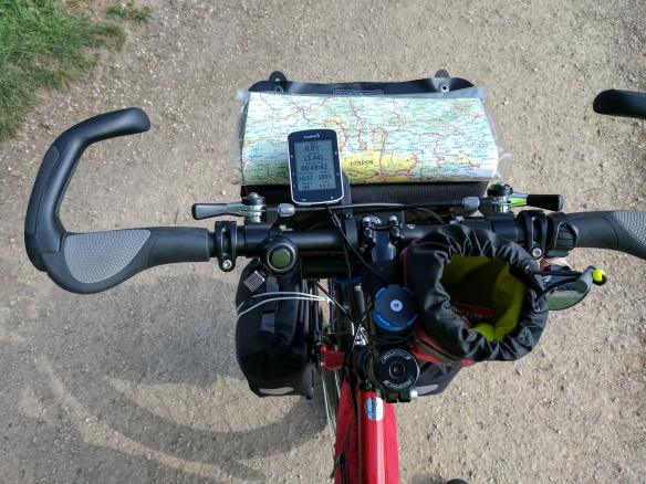
I also used Google Maps in ‘Direction’ mode (cycle routes) for final approaches to campsites or shops in major conurbations. I clipped the Smartphone to the Quadlock adaptor on my handlebars for that.
Google MyMaps
Google allows you to create your own map overlay, detailing the route (using GPX files) and any feature or point of interest (POI) you choose to record. Open Google Maps on your computer and select “Your Places -> Maps” from the menu and then select “Create Map”. You can upload your GPX file (see later about getting NSCR GPX files).
Here is the Map I created for the North Sea Cycle Route http://bit.ly/2DgZuX5 – I added POI before setting out (on my home computer) and added new POIs as I progressed (using the Smartphone MyMaps App)
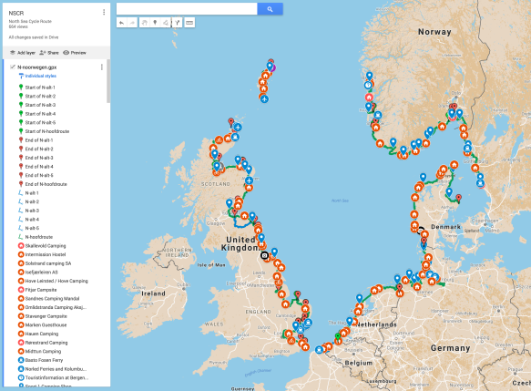
This map shows the GPX route (most of it), campsites, ferries and other points of interest. I will upload and share my photos in future, which will be geographical tagged and placed on the map using the coordinates recorded when the photograph has been taken.
My intuition, or lack of signposts, would promote me to open MyMaps on my phone and check my location. I could quickly see if I was on the right track and adjust my route accordingly. This became my preferred means of navigation.
Viewranger (Android and iOS)
This is now my preferred Navigation App for the UK. You can buy the Landranger 1:50,000 series for England, Scotland and Wales for £90, sometimes less during promotions. I only buy paper copies for the most popular areas. I use Bing Maps on my computer for larger scale OS maps, as they have a license and use is free at https://www.bing.com/maps (select Ordnance Survey Map from the menu). Bing Maps gives you free UK coverage at 1:25,000 too but only online.
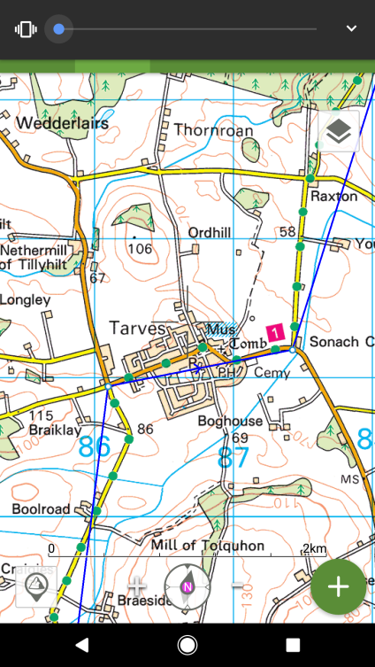
The map above shows the blue GPX route, roughly following the ‘green dot’ OS map cycle route, numbered 1 – National Cycle Route 1 – red square
Viewranger is now used all of the time for walking and cycling in the UK.
Backcountry Navigator Pro (Android)
BCN was my favourite App for many years. It is only available for Android and you can download Ordnance Survey Maps (both 1:25,000 and 1:50,000) for free. However, it is a bit cumbersome to select areas to download. The license to use these maps is through Bing Maps and could be revoked in future.
I still use BCN to access offline 1:25,000 maps for the UK, for walking and hiking, but usually as a backup to paper maps.
Garmin 520
There are many Garmin devices, the more expensive ones are able to use map navigation. I prefer to spend my money on a good Smartphone, which is multi-functional and easily outperforms the Garmin for navigation, other than perhaps battery life.
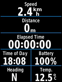
I use my Garmin 520 to navigate by using the compass and direction display fields. My ‘home’ screen on the device shows speed, distance, elapse time, time of day and compass (N, NE, E, SE, S, SW, W, NW). It was easy to quickly see which direction you are going. If this was inconsistent with my mental mind map, then I’d stop to check location with your smartphone. I used this a lot. It was not unusual to be cycling in the opposite direction to the one I had planned.
I did experiment with downloading maps to the Garmin 520. You can download custom cycle maps from garmin.openstreetmap.nl – this excellent site generates cycle specific routable gmapbmap.img files which can be copied on to the \garmin folder on the device via a USB connection, replacing the default generic gmapbmap.img file (keep a copy of the original). I could download about 65MB of map data in sections. I needed 6 sections to cover the whole of the NSCR and stored the future map images on my Smartphone, downloading those to the Garmin when I needed them via a USB cable. Google “Garmin gmapbmap” to find further technical information. There will be a Youtube video I am sure.
This took some patience and skill to achieve. To be honest I gave up using it for navigation. It seemed to have an inverse impact on the performance of the device.
However, the Garmin 520 is a great device for recording your route and acting as your odometer, thermometer, altimeter, speedometer, compass and clock. It can do many more things too, like heart rate and cadence if you get the extra sensors, but I shall not go into that.
Each day I recharged the device with my Anker Battery pack after first syncronising the days’ data with Garmin Connect – the Smartphone companion App. This needed an internet connection to work, but at least it syncronised it to the web to store your cycling data ‘in the cloud’.
The Garmin performed faultlessly for 55 days and I now have a complete, detailed record of my journey which is displayed in all its glory on my Garmin website account progress pages.
Paper Maps
It takes a lot to persuade me to use anything other than a paper map. Reading and using them is in my DNA. They are peerless when trying to plan ahead. SatNav takes you where you want to go, a map will take you to somewhere new!
For the UK, I was happy to dispense with paper maps, as I knew the terrain reasonable well, having toured extensively in the UK. For Europe, I purchase a number of paper maps from www.stanfords.co.uk – that mecca of a map shop in Covent Garden, London:
- Norway – Freytag and Berndt Norwegen Süd 1:250,000
- Sweden – Norstedts 1:90,000 Cykelkarten Series
- Denmark – Cykelkort Danmark 1:500,000
- Germany – ADFC-Radtourenkarte 1:150,000 Kart 5,7
- The Netherlands – De Sterkste Fietskaart Nederland (Noord and Suid)
- Belgium – none – I used Google Maps
- France – none – I used Google Maps
- UK – OS Landranger and Sustrans Maps, especially the London Map to navigate the City
- Transport for London cycling route maps are free at https://tfl.gov.uk/modes/cycling/routes-and-maps
Signposts
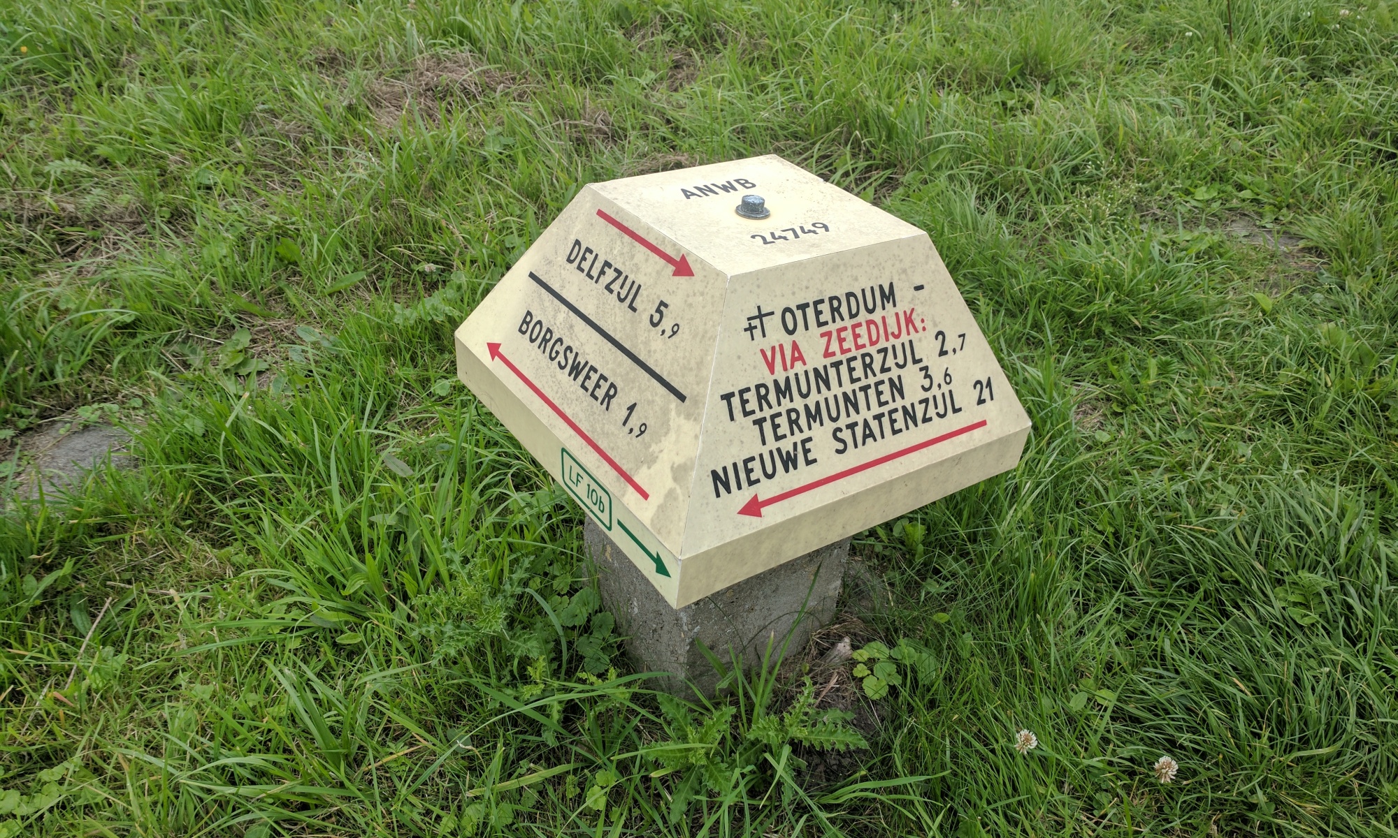
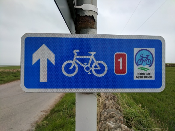
For most of the NSCR, I kept my eyes open for the signposts. After a while, your eyesight gets acutely tuned to these small navigation aids. I could spot the blue National Cycle Route 1 signs in the UK from quite a distance. Norway signs are excellent. Swedish signs needed repainting, but Denmark, Germany and The Netherlands signs are top notch. I love the Dutch ‘mushroom’ navigation posts.
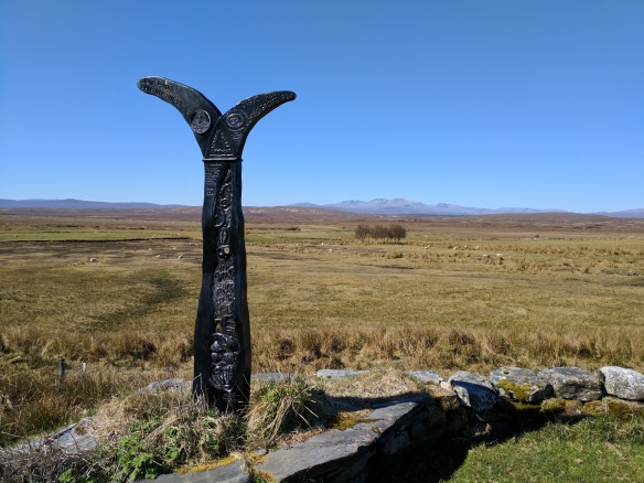
The picture shows the wonderful National Cycle Route signposts, usually painted in wild colours. This one is in Sutherland, Scotland.
90% of my navigation used signposts.
Intuition
Over the years I have developed an uncanny ability to stop when I know I am going in the wrong direction. My pigeon like brain senses something is wrong. It might be the direction the sun is shining or the position of the wind turbines or track conditions, but a combination of subconscious inputs say “Stop”. I check my smartphone. My intuition is usually right.
But not always. I have cycled for several hours in the wrong direction, having missed a turn. My record is 10 miles. Day dreaming again.
GPX files
The foundation of my adventures is GPX files. I downloaded routes from www.northsea-cycle.com and uploaded these into Viewranger and Google MyMaps.
Unfortunately, this website will be closed at the end of 2017, so if you cannot find the GPX files on the internet, please contact me and I will send them to you. I have not been able to find them elsewhere on the internet, although a number of commercial sites have seized an opportunity to draw you into their worlds. The files will be out of date until new ones become available.
I’d share my own Garmin generated GPX files, but prefer to save the embarrassment of all the wrong turns and shortcuts I have taken. You will inevitably do the same.
