
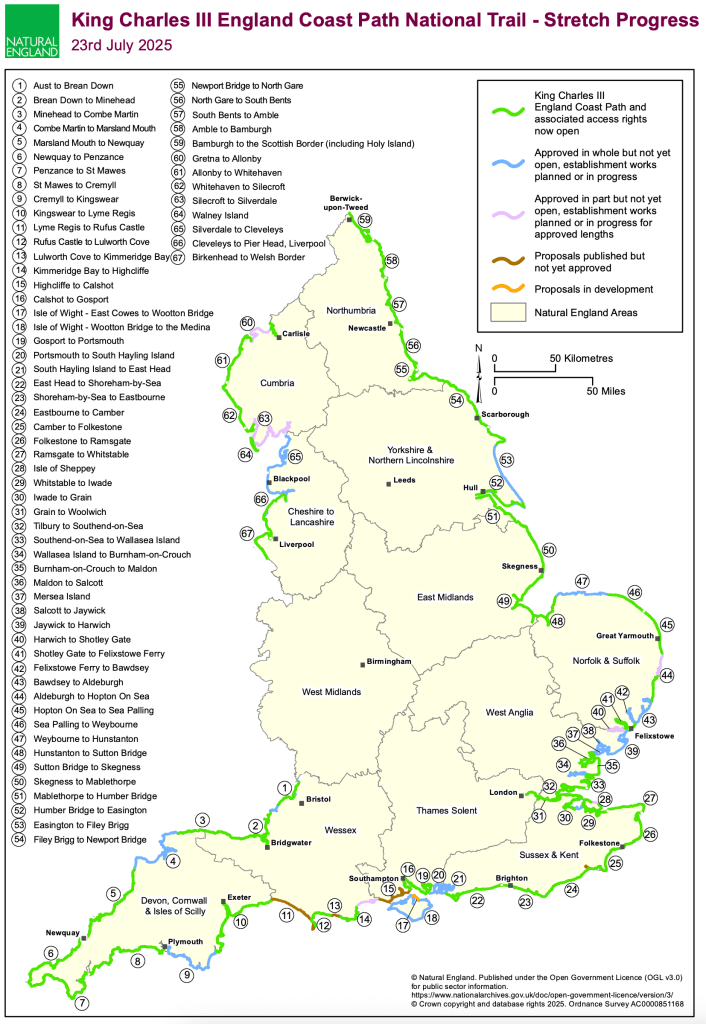
The new King Charles III England Coast Path will be completed in 2025. I walked much of what had opened between 2021 and 2024, taking public ferries mostly, but returning later to walk estuaries and islands as the formal paths opened: Essex estuaries, the Solent Way, and other small sections unwalked. I walked 2,300 miles in 110 days, yet the KCIIIECP should be 2,687 miles when fully open. The Natural England overview map beow gives current status, and I will update this from time to time. The definitive status can be found on the www.gov.uk website.
I have written about my journey, with a working title The Coast is Our Compass, and hope to publish early in 2026. I am building a digital map to accompany this book, and this is available to view now, by following the link below. This map reflects current status too, and the overlay with the route I walked and it shows geology, art, nature, news, and much more – the objective being to show the interplay between these elements and points of interest. The map has been built with ESRI’s ArcGIS and will develop further over time to show all the National Trails and other journeys I have taken. Click on the link below to open a new window for this map.
King Charles III England Coast Path Experience Map
King Charles III England Coast Path Experience Map – MOBILE version, for use on the trail.
Please use my LinkTree for further developments
The status of the KCIIIECP from Natural England below:
I encourage you to explore the Natural England government website for the latest information. Regional Maps can be found with this link, and usefull Leaflets are available too.
I started walking the path from Cromer in September 2021 (where I completed the 19 National Trails in 2016) and finished in June 2024. A total of 2,400 miles in 110 days (116 not counting half-days). I like ferries, so I used public services unless the inland estuary seemed pleasant enough – specifically in Suffolk and Essex. I crossed the Thames at Gravesend to avoid central London (a ferry service now cancelled) and I caught the hovercraft to Ryde on the Isle of Wight, returning to the mainland at Lymington and then to Bournemouth and the start of the SWCP.
Read my blog posts for a more detailed description of my experiences, I have listed these below:
Lastly, I would really welcome feedback on this new map, and I am seeking collaborators who would like to help me build a rich picture of what it is like to walk a National Trail. This is my Contact link.

Loved reading this thaank you
LikeLiked by 1 person
I want to walk the whole coastline in England and Scotland
LikeLiked by 1 person
The distance is nothing, only the first step is difficult. Make a start.
LikeLike